Log in
All resources
Create a design
33,111 Free Images of Composite Map
bibliothèque nationale de france
a map of the british empire in america with the french and spanish settlements adjacent thereto
1730s maps of the caribbean
maps
atlas géographique des quatre parties du monde (delisle)
coding da vinci: süd 2019
leibniz institute for east and southeast european studies
map of paris by jouvin de rochefort (boutier 112)
engraving
british library
backs of postcards in curt teich postcard archives
postcards of clinton, oklahoma
atlas géographique des quatre parties du monde (delisle)
map of europe by guillaume delisle (1700)
beschreibung der städt der welt - braun & hogenberg - btv1b52512111k
hierosolyma clarissima totius map by braun & hogenberg
atlas géographique des quatre parties du monde (delisle)
map of italy by guillaume delisle (1700)
beschreibung der städt der welt - braun & hogenberg - btv1b52512111k
hierosolyma urbs sancta map by braun & hogenberg
lawrence h. slaughter collection of english maps, charts, globes, books and atlases
nypl lionel pincus and princess firyal map division
claes jansz. visscher (i)
joannes van doetecum (i)
postcards of navajo county, arizona
curt teich postcard archives
john rocque's 1746 map of london
details of old maps of london
old submaps of paris 5e arrondissement
porte saint-victor (paris)
juliana of the netherlands in 1969
burgerzaal
1794 maps of the holy roman empire
english-language maps of europe
german-language maps from ios map collection
18th-century maps of the black sea
bern city map of 1638 by matthäus merian
baroque
map of paris by jouvin de rochefort (boutier 112)
historical images of hôtel de ville de paris
cartography
maps
british library - off the map alice collection - gardens
collections of the british library
british library - off the map alice collection - gardens
collections of the british library
british library - off the map alice collection - gardens
collections of the british library
1730s maps of south carolina
old maps of north america
curt teich postcard archives
postcards of miami, oklahoma
map of maastricht by willem and johannes blaeu (1649)
city gates in maastricht
dutch baroque architecture
mans spoor-dijkema
bern city map of 1638 by matthäus merian
baroque
maps
city
a map of the british empire in america with the french and spanish settlements adjacent thereto
maps in the library of congress
a map of the british empire in america with the french and spanish settlements adjacent thereto
maps in the library of congress
a new & correct map of england and wales (foster)
1750s maps of england
a map of the british empire in america with the french and spanish settlements adjacent thereto
1730s maps of the caribbean
works after map of amsterdam, 1544
maps in the rijksmuseum amsterdam
henricus hondius ii, nova totius terrarum orbis geographica ac hydrographica tabula, 1630
eran laor cartographic collection
atlas des anciens plans de paris by imprimerie nationale, 1880 from bhvp
map of paris by jouvin de rochefort (boutier 112)
media contributed by university of illinois urbana-champaign university library
1702 maps of africa
atlas des anciens plans de paris by imprimerie nationale, 1880 from bhvp
18th-century maps of paris
atlas des anciens plans de paris by imprimerie nationale, 1880 from bhvp
map of paris by jouvin de rochefort (boutier 112)
paintings by antônio parreiras in the museu antônio parreiras
1910s paintings by antônio parreiras
old submaps of paris 5e arrondissement
turgot map of paris – derivative files
turgot map of paris – derivative files
proletarian literature
map of maastricht by willem and johannes blaeu (1649)
jekerkwartier (maastricht)
cartography
maps
atlas géographique des quatre parties du monde (delisle)
map of scandinavia by guillaume de l'isle (1706)
atlas géographique des quatre parties du monde (delisle)
map of scandinavia by guillaume de l'isle (1706)
map of maastricht by willem and johannes blaeu (1649)
first medieval city wall of maastricht
turgot map of paris, kyoto university library – derivative files
hôtel de guénégaud (quai de nevers)
a map of the british empire in america with the french and spanish settlements adjacent thereto
1730s maps of the caribbean
a map of the british empire in america with the french and spanish settlements adjacent thereto
1730s maps of the caribbean
a map of the british empire in america with the french and spanish settlements adjacent thereto
1730s maps of central america
a map of the british empire in america with the french and spanish settlements adjacent thereto
1730s maps of the caribbean
zur geschichte der kartographie nordalbaniens (map reconstructions)
coding da vinci: süd 2019
map collection of leibniz-institut für ost- und südosteuropaforschung
1733 maps of europe
a map of the british empire in america with the french and spanish settlements adjacent thereto
maps in the library of congress
map of paris by braun & hogenberg - derivative files
rue des archives (paris)
map of paris by braun & hogenberg - derivative files
porte barbette
map of vienna by jacob hoefnagel
roter turm, vienna
brazilian paintings in the museu antônio parreiras
antônio rafael pinto bandeira
historical images of graben (vienna)
map of vienna by jacob hoefnagel
historical images of the place dauphine (paris)
place dauphine on maps
history of whitby, north yorkshire
british library maps collections
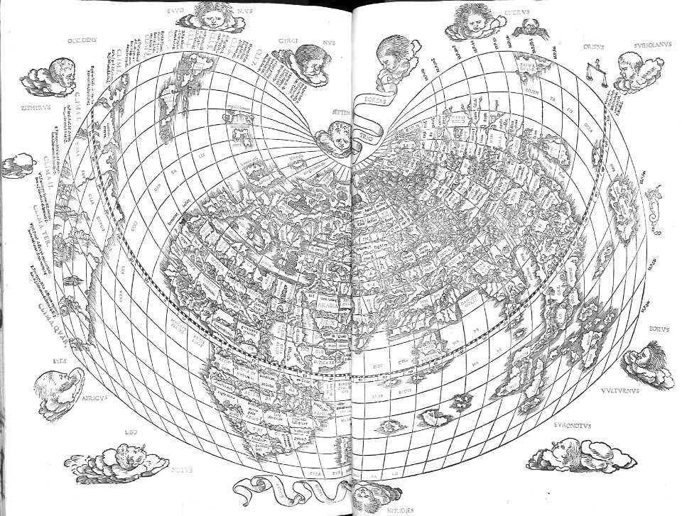
nicolas sanson. “mappe-monde, ou carte generale du monde.”
map of the bosphorus strait by guillaume sanson (1665)
grigory anikiyevich kachalov
mikhail makhaev
map of maastricht by willem and johannes blaeu (1649)
first medieval city wall of maastricht
prints by romeyn de hooghe
1689 map of haarlem
early netherlandish painting
t and o map
a map of the british empire in america with the french and spanish settlements adjacent thereto
bibliothèque nationale de france
a map of the british empire in america with the french and spanish settlements adjacent thereto
bibliothèque nationale de france
a map of the british empire in america with the french and spanish settlements adjacent thereto
bibliothèque nationale de france
a map of the british empire in america with the french and spanish settlements adjacent thereto
bibliothèque nationale de france
a map of the british empire in america with the french and spanish settlements adjacent thereto
bibliothèque nationale de france
a map of the british empire in america with the french and spanish settlements adjacent thereto
bibliothèque nationale de france
a map of the british empire in america with the french and spanish settlements adjacent thereto
bibliothèque nationale de france
a map of the british empire in america with the french and spanish settlements adjacent thereto
bibliothèque nationale de france
a map of the british empire in america with the french and spanish settlements adjacent thereto
bibliothèque nationale de france
a map of the british empire in america with the french and spanish settlements adjacent thereto
bibliothèque nationale de france
a map of the british empire in america with the french and spanish settlements adjacent thereto
bibliothèque nationale de france
a map of the british empire in america with the french and spanish settlements adjacent thereto
bibliothèque nationale de france
a map of the british empire in america with the french and spanish settlements adjacent thereto
bibliothèque nationale de france
a map of the british empire in america with the french and spanish settlements adjacent thereto
bibliothèque nationale de france
a map of the british empire in america with the french and spanish settlements adjacent thereto
bibliothèque nationale de france
a map of the british empire in america with the french and spanish settlements adjacent thereto
bibliothèque nationale de france
a map of the british empire in america with the french and spanish settlements adjacent thereto
bibliothèque nationale de france
a map of the british empire in america with the french and spanish settlements adjacent thereto
bibliothèque nationale de france
a map of the british empire in america with the french and spanish settlements adjacent thereto
bibliothèque nationale de france
a map of the british empire in america with the french and spanish settlements adjacent thereto
bibliothèque nationale de france
a map of the british empire in america with the french and spanish settlements adjacent thereto
bibliothèque nationale de france
a map of the british empire in america with the french and spanish settlements adjacent thereto
bibliothèque nationale de france
a map of the british empire in america with the french and spanish settlements adjacent thereto
bibliothèque nationale de france
a map of the british empire in america with the french and spanish settlements adjacent thereto
bibliothèque nationale de france
maps of oxia palus quadrangle
mars topography
a map of the british empire in america with the french and spanish settlements adjacent thereto
1730s maps of the caribbean
city walls of vienna
views of vienna
maps of ancient israel by philippe de la rué
map of modern syria by philippe de la rué
historical images of vienna
schottenkirche, vienna
nature
maps
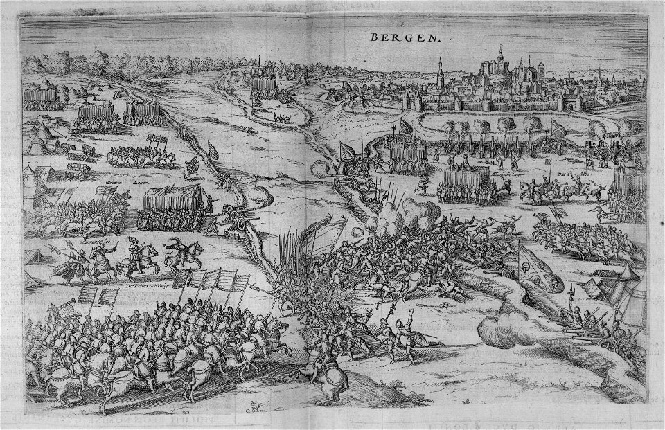
military equipment of muscovite russia
details of sigismund's map of moscow
maps from traité de la police, bibliothèque nationale de france
fifth map of paris from traité de la police
maps from traité de la police, bibliothèque nationale de france
first map of paris from traité de la police
background
maps
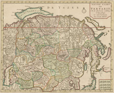
map collection of leibniz-institut für ost- und südosteuropaforschung
18th-century maps of siberia
paintings by antônio parreiras in the museu antônio parreiras
portrait paintings by antônio parreiras
lawrence h. slaughter collection of english maps, charts, globes, books and atlases
nypl lionel pincus and princess firyal map division
2801 - 2900 of 33,111
Next page
/ 332


![Lutetia or first plan of the city of Paris taken from Cesar, Strabo, the Emperor Julian and Ammiam Marcellin [Digitized still image] / By MLCDLM, Antoine Coquart](https://cdn.creazilla.com/illustrations/10001224733/lutetia-or-first-plan-of-the-city-of-paris-taken-from-cesar-strabo-the-emperor-julian-and-ammiam-marcellin-digitized-still-image-by-mlcdlm-antoine-coquart-md.png)